Google Earth
I have seen a very colorful array of sports equipment being used by people over the last few weeks. Various wraps and supports, special ''wicking" clothes, shoes of astronomical price, and (I still laugh when I see one) those silly side-view mirrors on helmets. Personally, I prefer to have as little on my when I am out as possible. Get your mind out of the gutter, you silly rabbit. Of course I am fully clothed, I just don't like the have a lot of other things on my person. I have, however, found several items that have become invaluable to my new weight-loss routine. Over the coming week, I will post on each and every one of them, starting with my current favorite, Google Earth.
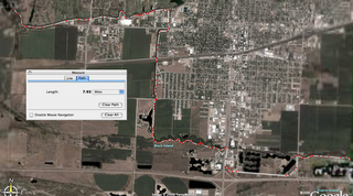
 Actual physical results are so hard to see week-by-week, let alone day-by-day. Setting goals for individual work-outs provide me that sense of accomplishment that is key to keeping yourself going. Like I said, time and distance goals are key for me. I have used Google Earth to map out several main courses that take me by water fountains and get me the main amount of miles that I need to hit on my rides. When I come to the end of which ever one of those courses that I am on, I go freestyle a bit. I ride wherever I feel like riding. When I get home, I use Google earth to measure out the length of the course.
I know that there are all kind of programs that allow you to map out distances on roads, but so far only Google Earth has provided fairly up-to-date satellite imagery of the Kearney area that I can use to measure the distances of the trails, parking-lots, and other various places that I ride. I hate riding on the sidewalks by the roads, and will ride on virtually any other acceptable surface that I can find. The ability that Google Earth gives you to measure distances by snapping points absolutely anywhere on the map means that I have the freedom to go anywhere that I legally can and accurately know the distance.
Now, by this point I am sure you have thought to your self, ""Why doesn't he just get one of those cheap bike attachments that measures distances as he rides?" I'll tell you why. For me, those things have the same effect as that stupid clock does on my desk on Friday afternoons at work. They constantly draw my attention, and sap the fun out of the ride. I prefer to 'take a mental voyage' on my bike rides, or occupy my mind in any one of a thousand other ways. Not only that, Google Earth lets you plan courses ahead of time, and make adjustments before you are out on the road.
Click on the image below to get a larger view of my favorite course. The mapped course below shows you the Kearney Hike-and-Bike trail starting on the left at Cottonmill, and ending just outside of the Archway Monument by the interstate. Provides a lot of 'traffic free' miles. So, if you are wanting to do some off-the-track running or riding, Google Earth can be an amazing tool for mapping distances. So far, it is my favorite exersice tool.


0 Comments:
Post a Comment
<< Home